

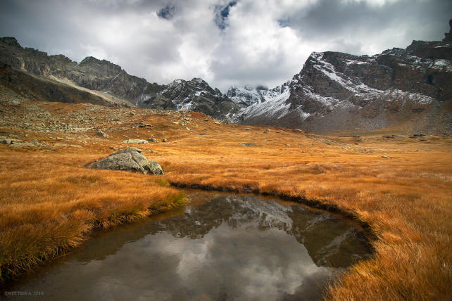
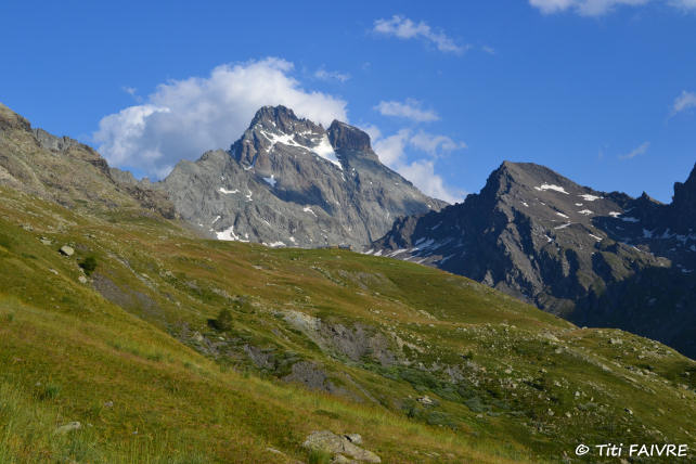
 Belvedere du Viso and lake Lestio


• Self-guided tour, 4 days
• Moderately difficult circuit, Children above 8 years old
• Altitude : 1760 to 2520 m
• Departure and arrival in Le Roux
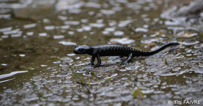
Here is a hike that takes you to the sources of Guil in the heart of a protected area, the Mont Viso Nature Reserve, which is home to an endemic species, the black salamander known as the Lanza Salamander, as well as many plant species. In an atmosphere "far away", you reach Lake Lestio, nestling at the foot of Mont Viso, emblematic summit of Queyras, shield of rocks and ice closing the Guil valley border with the piedmont and biotope par excellence of the ptarmigan and niverolles.
For athletes and / or contemplatives, possibility of staying one more day in the alpine circus of the Viso mountain in order to take advantage of this exceptional site and discover a relatively accessible Alpine environment.
- Stages -
Day 1 : Le Roux (1760 m) - La Monta (1670 m)
Elevation gain : 320 m - Elevation loss : 380 m - Distance : 9 km - Walking time : 3 hrs
You leave the Roux via the GR58 variant and cross the Bouchet stream before joining the forest track which rises gradually in the Brune wood to reach the Fusteit (2010 m) on the Abriès ski slopes. There, you join the GR58 which descends on Ristolas via the pond of Moussou (1920 m). Arrived at the bottom of the valley, you take the elegant wooden structure bridge which spans the torrent of Guil, you follow the GR58 which crosses Ristolas and you follow the left bank of the torrent to La Monta or l'Echalp (1700 m) . Accommodation in a gîte or bivouac.
Day 2 : La Monta (1670 m) - Refuge du Viso (2460 m) ou Lac Lestio (2520 m)
Elevation gain : 790 m ou 850 m - Distance : 10,2 ou 12,2 km - Walking time : 4 hrs
From Monta (or Echalp) you take the road which runs along the Guil on the right bank to Roche Ecroulée. You continue on this track on the right bank of the torrent until the Belvedere du Viso where you enjoy a privileged view on the North face of this giant of the Alps between France and Italy. From there, turn left on the path which rises in the pasture towards the Refuge du Viso. Depending on your preferences, take advantage of friendly accommodation at the Refuge or a bivouac at altitude near Lake Lestio.
Day 3 : Cirque de la Montagne du Viso (2520 m) - La Monta (1670 m) (Gîte ou Bivouac)
Elevation gain : to be defined - Elevation loss : 850 m (minimum) - Distance: 12,2 km - Walking time : 3 hrs
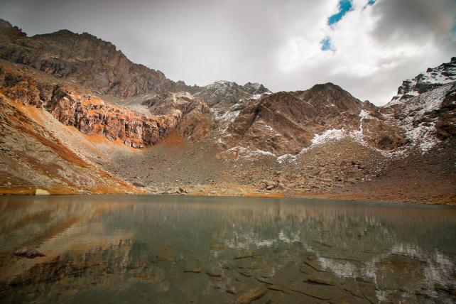
Take advantage of the morning to discover the exceptional site around Lake Lestio (Col Valante, Pointe Joanne, ...), without the donkeys who will wait for you wisely at the camp!
To descend into the valley, take the path that descends on the right bank of the Guil to the Viso belvedere where you join your ascent route, which you follow to Echalp or Monta.

Day 4 : La Monta (1670 m) - Le Roux (1760 m) par Abriès
Elevation gain : 290 m - Elevation loss : 200 m - Distance : 10 km - Walking time : 3 hrs
From Monta (or Echalp), join GR58 on the left bank of the Guil torrent and follow it downhill to Ristolas. At the exit of the village, leave the GR and continue on the left bank of the torrent on the forest track of the Bois de Jassaygues to join Abriès. Cross the village and take the road towards Roux, then recover the GR58 which rises in the forest. Then, leave the GR in the first hairpin around 1800 m above sea level and descend to the left by the path which joins the forest track below. Cross the stream and join the Roux by the departure route.
- Practical information -
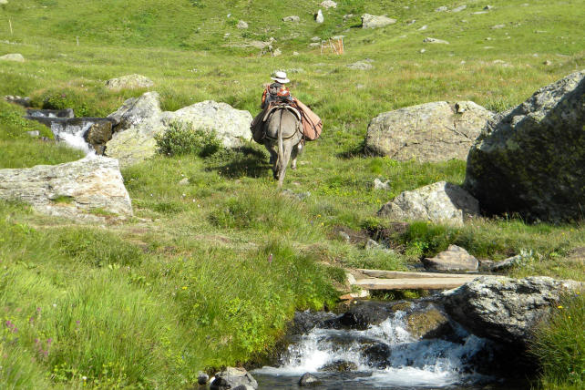
The donkeys
* They are intended to carry your luggage. Gregarious animals, they will appreciate your company but also that of their fellows and beyond 3 people, it would be better to travel with 2 donkeys for the comfort and well-being of all.
* Their equipment : Each donkey is equipped with a halter, a lunge, a wooden packsaddle and 2 large bags hung on each side of the packsaddle. A donkey can carry 30 kg, that is the luggage of 2 to 3 hikers.
The load must be perfectly balanced (15 kg on each side). Above the animal, only light loads (mattresses, etc.) can be placed, in order to avoid exhausting or unbalancing it.
* Donkey food and night : in most lodges, a park is set up for donkeys and we provide the necessary equipment to tie them up at night.
Preparation for your hike
We advise you to arrive at Le Roux the day before your departure in order to get to know and prepare your hike (study of the route). Accommodation is possible at the Cassu gite, opposite our base camp.
On the morning of departure, allow at least one hour for the preparation of the donkey and the organization of luggage.
Period
This hike can be done from July to October. From 15 September, some accommodations (gîtes, refuges, camping) may be closed.
IGN map
This circuit appears on the IGN map (1/25000 th) 3637OT - Mont Viso, St Véran, Aiguilles, Queyras.
Accommodation
For this hike, possibility of accommodation in a gîte / refuge or bivouac under tent (equipment not provided).
https://www.montourduqueyras.fr
Supplies
You must arrive with the necessary equipment for the duration of your stay. For the water, bring a water bottle per person and Micropur tablets.
Your luggage
In the Hautes-Alpes the climate is very contrasted: the heat of full sun during the day and surprising freshness at night.
So plan :
* walking shoes and light shoes for the evening,
* a change of clothes, a warm sweater, a hat for the sun,
* rainwear (waterproof poncho),
* water bottle, flashlight, notebook, pen, lighter, knife, string,
* pharmacy, protective cream and sunglasses,
* plastic bags to wrap the things in the bag (very effective in case of rain) and to bring your trash down,
* stove and kitchen equipment, tent and sleeping bag (if camping)
Your dog
According to regulations, your dog can accompany you on the trails of the Queyras Regional Natural Park provided that it is kept on a leash. After a period of adaptation and mutual observation, he will cohabit with the donkeys. However, it must be taken into account that this does not simplify the organization of your hike because it is sometimes difficult to manage everything at the same time: the donkey or donkeys, the children, the luggage, the map to follow the right path and... the dog ! Especially since it is sometimes necessary to keep away from the donkey with the dog on a leash and that there can be problems with the dogs that protect the flocks of sheep in the pastures. Dogs cannot sleep in the accommodation and, in general, a shelter is provided for them outside. Remember to let us know if you plan to hike with a dog.
Dogs are not allowed in the Viso nature reserve.
Your car and various equipment
During your hike, your car stays in one of the car parks in the hamlet of Roux d'Abriès.
- Prices and contact -
It includes the rental of a donkey equipped with a packsaddle, a halter, a lunge and two saddlebags.
Your accommodation and the possible transport of donkeys must be paid in addition.
4 days with 1 donkey : € 248
For more information :
06 82 48 09 99 or anerousin@orange.fr
To book this stay, please download and complete our rental contract and attach a deposit of 30% of the amount.
Download a printable version of this hike (Pdf)